


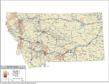
Population Density Map of Montana
| Dimensions: | 7.5 x 10.0 in (19.1 x 25.4cm) |
|---|---|
| Publisher or Printer: | World Trade Press |
| Published in: | Traverse City, MI |
| Year Published: | 2020 |
An isopleth thematic map of Montana using shading to indicate density to show population distribution. Also shows county borders, county names, major and secondary cities, interstate highways, U.S. and state highways.
Features on This Map:
- Legend
- County Borders
- County Names
- Coastline
- County Seat Location Icon
- County Seat Location Name
- Major City Located by Icons
- Major City Names
- Major River Systems
- Secondary River Systems
- Major River Names
- Major Lakes
- Lake Seas Names
- Lake and Sea Fill
- Projection: Lambert Conformal Conic
View, Print, Download
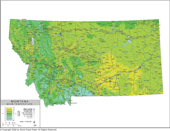
Mean Temperature Map of Montana
| Dimensions: | 7.5 x 10.0 in (19.1 x 25.4cm) |
|---|---|
| Publisher or Printer: | World Trade Press |
| Published in: | Traverse City, MI |
| Year Published: | 2020 |
An isopleth thematic map of Montana that uses lines connecting places of equal distribution to show annual mean temperature in high detail. Also shows county boundaries in outline, county seats, major cities and towns, major and secondary highways, major river systems and lakes.
Features on This Map:
- Legend
- County Borders
- County Names
- Lakes and Seas Names
- Lakes Fill
- Coastline
- County Seat Location Icon
- County Seat Location Name
- Major City Located by Icons
- Major City Names
- Secondary Cities Located by Icon
- Secondary City Location Names
- Major River Systems
- Secondary River Systems
- Major River Names
- Interstate Highways
- Interstate Highway Labels
- U.S. Highways
- U.S. Highway Labels
- State Highways
- State Highway Labels
- Projection: Lambert Conformal Conic
View, Print, Download
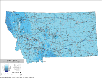
Annual Precipitation Map of Montana
| Dimensions: | 7.5 x 10.0 in (19.1 x 25.4cm) |
|---|---|
| Publisher or Printer: | World Trade Press |
| Published in: | Traverse City, MI |
| Year Published: | 2020 |
An isopleth thematic map of Montana that uses lines connecting places of equal distribution to show total yearly rainfall in high detail. Also shows county borders with county names, state capital, major and secondary cities and towns, major river systems and lakes.
Features on This Map:
- Legend
- County Borders
- County Names
- Lakes and Seas Names
- Lakes Fill
- Coastline
- Latitude & Longitude Graticules
- County Seat Location Icon
- County Seat Location Name
- Major City Located by Icons
- Major City Names
- Secondary Cities Located by Icon
- Secondary City Location Names
- Major River Systems
- Secondary River Systems
- Major River Names
- Interstate Highways
- Interstate Highway Labels
- U.S. Highways
- U.S. Highway Labels
- State Highways
- State Highway Labels
- Projection: Lambert Conformal Conic
View, Print, Download
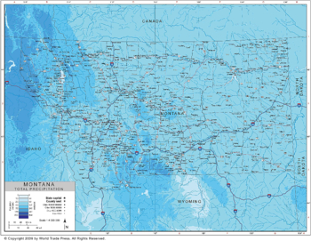
Annual Precipitation Map of Montana Region
| Dimensions: | 7.5 x 10.0 in (19.1 x 25.4cm) |
|---|---|
| Publisher or Printer: | World Trade Press |
| Published in: | Traverse City, MI |
| Year Published: | 2020 |
An isopleth thematic map of Montana that uses lines connecting places of equal distribution to show total yearly rainfall in high detail. Also shows county borders with county names, state capital, major and secondary cities and towns, major river systems and lakes.
Features on This Map:
- Legend
- County Borders
- County Names
- Lakes and Seas Names
- Lakes Fill
- Coastline
- Latitude & Longitude Graticules
- County Seat Location Icon
- County Seat Location Name
- Major City Located by Icons
- Major City Names
- Secondary Cities Located by Icon
- Secondary City Location Names
- Major River Systems
- Secondary River Systems
- Major River Names
- Interstate Highways
- Interstate Highway Labels
- U.S. Highways
- U.S. Highway Labels
- State Highways
- State Highway Labels
- Precipitation Data Outside of State
- Projection: Lambert Conformal Conic
View, Print, Download
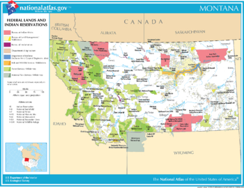
2003 Map of Montana - Federal Lands and Indian Reservations
| Dimensions: | 7.5 x 10.0 in (19.1 x 25.4cm) |
|---|---|
| Publisher or Printer: | World Trade Press |
| Published in: | Traverse City, MI |
| Year Published: | 2020 |
Montana - Federal Lands and Indian Reservations
The National Atlas of the United States of America, U.S. Geological Survey, 2003
View, Print, Download
Copyright © 1993-2025 World Trade Press. All rights reserved.
