


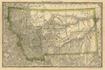
1881 Map of Montana
| Dimensions: | 7.5 x 10.0 in (19.1 x 25.4cm) |
|---|---|
| Publisher or Printer: | World Trade Press |
| Published in: | Traverse City, MI |
| Year Published: | 2020 |
Scale ca. 1:2,000,000. Railroad maps, Description derived from published bibliography.
Indexed county map of Montana with a new and original compilation and index, designating all post office towns and railroad stations.
Rand McNally and Company.
View, Print, Download
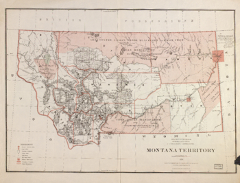
1879 Map of Montana
| Dimensions: | 7.5 x 10.0 in (19.1 x 25.4cm) |
|---|---|
| Publisher or Printer: | World Trade Press |
| Published in: | Traverse City, MI |
| Year Published: | 2020 |
Relief shown by hachures. Scale from Stephenson's Civil War, 1989. At head of title: Department of the Interior, General Land Office, J.A. Williamson, Commissioner. Map indicates range and township lines, cities and towns, county names and boundaries, county seats, military and Indian reservations, railroads, and relief by hachures. The map has been annotated in ink to show "Wolf Pt. Agency," and "Poplar Cr. Agency" on the Missouri River. Mileages from these agencies are indicated to the right of the map. Description derived from published bibliography. Civil War maps, S190 Scale [ca. 1,267,200].
Montana territory / compiled from the official records of the General Lane Office and other sources by C. Roeser, principal draughtsman G.L.O.; photo lith. & print. by Julius Bien.
Roeser, C. (Charles)
View, Print, Download
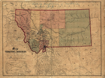
1865 Map of Montana
| Dimensions: | 7.5 x 10.0 in (19.1 x 25.4cm) |
|---|---|
| Publisher or Printer: | World Trade Press |
| Published in: | Traverse City, MI |
| Year Published: | 2020 |
Relief shown by hachures. Includes inset of "Map showing the routes from the Missouri River to Fort Laramie, where they connect with ... large map." copy annotated in blue pencil: "Working diagram of Montana brought up to Feb. 1, 1871." Scale [ca. 1:1,500,000] (W 177040'--W 103000'N 49000'--N 42000').
Map of the territory of Montana with portions of the adjoining territories : showing the gulch or placer diggings actually worked and districts where quartz (gold & silver) lodes have been discovered to January 1st 1865 / drawn by W.W. de Lacy for the use of the first legislature of Montana.
De Lacy, W. W. 1819-1892. (Walter Washington)
View, Print, Download
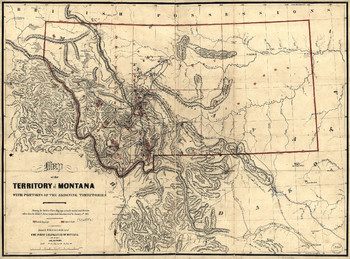
1865 Map of Montana
| Dimensions: | 7.5 x 10.0 in (19.1 x 25.4cm) |
|---|---|
| Publisher or Printer: | World Trade Press |
| Published in: | Traverse City, MI |
| Year Published: | 2020 |
Relief shown by hachures. copy annotated in blue pencil on verso: Map of Montana terr. 1865, with suggestions as to new post routes & pos. made in..., A.G. Lawrence's report of December 13 1865. ... Scale [ca. 1:1,500,000] (W 177040'--W 103000'N 42000').
Map of the territory of Montana with portions of the adjoining territories: showing the gulch or placer diggings actually worked and districts where quartz (gold & silver) lodges have been discovered to January 1st 1865 / drawn by W.W. de Lacy for the use of the first legislature of Montana.
De Lacy, W. W. 1819-1892. (Walter Washington)
View, Print, Download
1865 Map of Montana
| Dimensions: | 7.5 x 10.0 in (19.1 x 25.4cm) |
|---|---|
| Publisher or Printer: | World Trade Press |
| Published in: | Traverse City, MI |
| Year Published: | 2020 |
Relief shown by hachures. copy annotated in blue pencil on verso: Map of Montana terr. 1865, with suggestions as to new post routes & pos. made in..., A.G. Lawrence's report of December 13 1865. ... Scale [ca. 1:1,500,000] (W 177040'--W 103000'N 49000'--N 42000').
Map of the territory of Montana with portions of the adjoining territories: showing the gulch or placer diggings actually worked and districts where quartz (gold & silver) lodges have been discovered to January 1st 1865 / drawn by W.W. de Lacy for the use of the first legislature of Montana.
De Lacy, W. W. 1819-1892. (Walter Washington)
View, Print, Download
Copyright © 1993-2025 World Trade Press. All rights reserved.
